 Live Music Archive
 Librivox Free Audio
 Metropolitan Museum
 Cleveland Museum of Art
 Internet Arcade
 Console Living Room
 Books to Borrow
 Open Library
 TV News
 Understanding 9/11
tv 9 News Now at 6am CBS October 29, 2012 6:00am-7:00am EDT
6:00 am

powerful wintry weather system. this super storm causing havoc over 800 miles from the east coast to the great lakes. wusa9 has the full coverage of how the washington area is bracing for this storm. again good morning. thank you for watching 9news now at 6:00 a.m. i'm andrea roane. mike hydeck is following your tweets and facebook postings. monika samtani is here. she's going to be back in a moment with timesaver traffic. there are those of you who are saying we have to get to work. how do we get there? she'll help you get around. right now howard bernstein has our weather first and the latest on sandy's path. you were saying earlier, howard, this is a battle between summer and winter storm. we're caught in the middle. >> right. this is such a ray thing. it only really happen -- rare thing. it only really happens the end of october when you have the tropical season in play. you get the upper level winds you might see more in the wintertime. later in november it will be too cold for the tropical
6:01 am

system usually to be in play this far north. we only have a week or two window of opportunity every year to get this. >> this is rare. i don't remember anything like this. >> you may never see this again. let's hope so. just an extreme, extreme weather event. kudos for everybody for taking it seriously, for canceling schools, work, transit. i think that's easily the right call and calling the evacuations. let's get you going with a look at our day plan other this monday morning. we've got rain which has picked up. moderate rain right now. by noon heavy rains and wind going on there. temperature steady if not falling. right now 53 degrees with moderate rain. we've got hurricane force wind warnings from the mid-atlantic to the northeast. this is where i think the hurricane center blew it. they thought, you know, past cape hatteras, we won't issue hurricane or tropical storm warnings because we think it's going to be an extra tropical
6:02 am
storm. we'll confuse everybody by going to another warning system. this is a hurricane for the chesapeake bay, the atlantic. even though it's a marine storm warning, tropical storm warning south of there. the worst of the winds will come into our region. we have winds gusting to 105 moving to the north. it's begun the turn. it was going northeast. now it's going northerly. it's going to turn more toward the northwest. maybe coming on shore by atlantic city 10:00, 11:00 tonight. the worst of the winds will be starting this evening overnight through lunch time tomorrow. qee have gusts here in the metro -- we could have gusts here in the metro above hurricane strength. it's going to cause some damage and rainfall. some areas could get more than a foot. potentially six inches plus around here. i'll be back with more in a few minutes. right now here's monika with timesaver traffic. i was happy to see the grocery stores and harmed ware stores busy over the -- hardware stores busy over the weekend. that meant everyone was preparing. that's what you needed to do.
6:03 am
it's surely coming in as howard has been telling us. it's going to affect our roads. everybody has planned early. if you normally use metro, while it's closed including rail bus, metro access, ride on, all those services have been suspended. we've been on the found with metro's spokesperson and he tells us they will not decide what they're going to do till tonight. if you're planning to head over on any of these roads keep in mind that those are prone to flooding and they're already shut down in parts of those three roads. now let's take a quick look outside just to show you what it looks like on the roads. it's wet and volumes are light but there are still people that need to get to work. so please give yourself the extra time you'll need to deal with conditions today. i'll have more of course throughout the morning broadcast. back to you. the coast empties out as the storm moves in. as hurricane sandy sets in on
6:04 am

rehoboth beach in delaware, businesses and residences are boarded up as people are orpded to evacuate. -- ordered to evacuate. our live team coverage begins with kristin fisher live atra hoe both -- live at rehoboth beach. >> reporter: it's getting a lot colder. my hands are starting to feel it. the last time i saw you i was a whole lot drier. now we're on the north side of rehoboth beach, the bayside. this does a place called the northside play ground, a marina where lots of folks keep their boats. most of them are gone. this is harbor road, part of a parking lot here at the north shore playground. it is completely submerged in water. if you go a little farther out, it goes up well over my knees. i'm going to stick right about here. this is precisely why we're under a level two travel advisory right now throughout
6:05 am

delaware but especially here in rehoboth beach. i want to show you some video right now that one of our photographers shot a few hours ago driving on another part of the north side of rehoboth beach. he's driving through at least 3 feet of water here as he's trying to get to our live shot location. it just goes to show you how dangerous these conditions are. this level two travel advisory means that nobody does allow -- nobody is allowed to be out driving except for emergency personnel, essential personnel, a few members of the media like ourselves but the goal is to not have what happened like it did during irene. keep in mind we are still high -- i lost track of what time it is but high tide is not until 7:30 and the wind keeps on increasing. the tide's coming n. we've got more and more rain so all this water is just going to get so much worse and especially when you think that we are only at
6:06 am

the very, very beginning of this storm. we still have at least 36 hours to go here in rehoboth beach with hurricane sandy. and this has been going on since yesterday at around 4:00 in the afternoon. that's when we first started to really feel wow, that is probably the first big gust that i felt since we've been out here. we've been seeing really sustained winds that have been increasing throughout the night. but really within the last half- hour or so is when we first started to feel these huge gusts just coming in from the beach. we've got wave heights of about well over 20 feet now off the shore and it's just going to keep on getting worse. yesterday i talked with the governor of delaware. he was saying that already yesterday afternoon it was looking so much worse then that it was at the peak of hurricane irene. so that's why we are under a mandatory evacuation order. i have not seen just driving around hardly anybody out on these roads. that's exactly what we want to
6:07 am

be seeing. just look at this water. it is still coming in. this wind when it comes in, it's blowing your car around. you just can't be driving through stuff like this. so high winds, lots of rain. i couldn't quite hear what you said but high winds, lots of rain. it's only going to be getting worse. if you're able to watch this from home, just stay there. you're in the best place to do it. we have businesses boarded up, folks staying in. most of the electricity is still on. we haven't seen a lot of power outages here in this part of rehoboth beach just yet. of course that could certainly change as hurricane sandy barrels even closer towards us. back to you guys. >> good advice right now as you still have power to power up all of those cell phones, smartphones, everything. good advice. live in rehoboth beach, delaware. koim is -- koim is at
6:08 am

chesapeake beach in calvert county. your boots were already covered by water in your area. >> reporter: we'll get to that in a little bit, andrea. good morning to you and to all of you who are watching at home. we are seeing a couple cars going up and down the roads here today. but we wanted to remind you if you still need to head outside and bring in a couple of things or grab a couple of things, it is cold, rainy as you can see and windy out here. maybe sure you have a winter -- a waterproof winter jacket and maybe some rain boots also. let's show you those flags we were showing you the last half- hour. so far here in chesapeake beach, we haven't southeastern the flags wave in a different direction. then we'll show you that puddle if we jump in here. the water has gone from here all the way up here. the boats are not rocking more. at this point all these boats
6:09 am

are tied down, getting ready to stay here for the storm. we'll show you video of preparing for the storm over the weekend. people putting up boards on their businesses and homes, getting sandbags and putting them in front of their doors and of course getting all their supplies here. you can still get to some of these gas stations in chesapeake beach this morning. this town as is all of the state of maryland is under a state of emergency. the mayor has asked that people stay home and make sure to prepare and as you said, andrea, keep your batteries charged. don't overuse your cell phones now in case the power does go out. back to you. >> thank you, ko im in chesapeake beach. now time to head across the potomac into virginia. jessica doyle is live from old town alexandria which is used to the flooding drill. jessica, howard says you can expect even more rain coming your way. >> reporter: absolutely. i'll tell you, andrea, it's
6:10 am

really picking up. at least the rain has been picking up. i'm surprised that we haven't really seen the huge wind gusts just yet. but let me tell you they are coming. the expectations are that wind gusts along the potomac, boaters will understand this are expected at 55 knots today. what that means, if you're looking at the bowford scale, that's one scale of checking wind. if you're a boater, you understand a lot of this stuff. but to translate it into normal person language, that is gail frs woindz -- force winds. wind is going to abhuge problem in the washington area bringing down trees. we've been telling you this throughout the coverage. obviously power problems are expected but it's also going to cause more problems along the potomac as howard was telling us earlier in the day. at one point the winds were going in one direction pushing out water into the bay. at another point they'll switch back and start pushing water back in. that causes problems for areas like old town alexandria. let me show you behind me.
6:11 am

we have nina's dandy. this is one of the river boats that is docked right here along the potomac. at some point i would imagine the owners of nina's dandy will make the decision. what happens when you see big waves rising, big flooding situations, these types of boats can get damaged when they're moored. sometimes they have to take them out and that's the safer choice. i want you to walk with me this way to give you a sense of what water levels are on the potomac river. i want to show you this dock we showed you the last half-hour. in just the last 30 minutes, we've already seen the water levels rise about half a foot. we are far away from high tide at this point. high tide at the potomac at this point is predicted about 8:45 this morning between low and high tide on a typical day, you see the water level rise by 3 feet. that is without the kind of rain being dumped on the washington area at this point.
6:12 am

we have another high tide around 8:45 p.m. that is going to be a serious one to watch. i predict at some point today we will see this water line rise above dock levels, jump and fill this area that typically get flooded here in old town alexandria. our photograph paul is giving you a look at the scene here. we're starting to see ponding on the roadways already. no real flooding at this point. but old town alexandria is used to flooding. the sandbags are out. about 10% of the businesses and homes we've seen here in old town have sandbags at the openings of doors and openings into the building. we're going to stay here on the scene all morning long. we'll watch the water level rise now. watch the wind and rain all of which are picking up at this point. with that i'll send it back to you guys in the studio. >> jessica doyle is reporting live and will be throughout the morning from old town alexandria. at 6:12 we want to take a quick look at some other
6:13 am

headlines this morning. the amber alert you may have heard about last night turned out to be a hoax. prince george's county police say the woman who claimed her three children were inside her stolen car lied. investigators believe the caller was not making up the part about her car being taken from a liberty gas station on central avenue in seat pleasant but when officers found the vehicle after 11:00 last night, no children were inside. the woman faces charges of making a false report. by now you've probably already stocked up on batteries and bottled water but there are some other things you can do to get ready in case the power goes out. charge your cell phone now. dim the brightness feature on your phone and turn off any unnecessary apps to conserve battery power. find your digital camera. make sure it has fresh batteries or the batteries are charged. if you experience storm damage, your insurance company will want pictures so it's important that that camera is ready to go. all the halloween decorations
6:14 am

you put out, take them down. even a small pumpkin can cause serious damage to your home or another person if it's picked up and hurled by strong winds. an important reminder as we're all worried about losing power, our web and social media teams have you covered whether you have power or not. starting this morning all of our newsroom wusa9 will be live streaming on our mobile site m.wusa9.com. so if you lose power, you can watch 9news on your tablet or mobile device, not just your apple devices or your ipads or iphones. across the board we've got you covered when you can -- you where can get the most up to date information. thousands of people are already relying on the 9news text alerts for all the latest information. text sandy to 25543. you'll be signed up immediately and start receiving 9news alerts to keep you safe and protected. we really want to hear from you and what you and your family are doing through this ordeal. so be sure to go to our
6:15 am

facebook page and report power outages, any damage and definitely send us your pictures. mike hydeck is watching facebook right now. we'll be hearing from you through that. you can also follow us on twitter at wusa9 or at topper's weather or at hbwx and at erica grow. so we've got you covered wherever you are and however you want to communicate with us. howard has the very latest on sandy and it's effect on the weather in our area. his forecast fir. monika has your traffic and the closings you need to be aware of. you're watching 9news now tracking hurricane sandy. we'll be right back. it's 6:15. (bell rings)

6:17 am

hi. yes? you know those delicious granola bunches in honey bunches of oats? i love those. we've added more to every box. really? wow! honey bunches of oats. make your day bunches better.
6:18 am

good morning. welcome back. we've joined on the phone by metro's spokesperson dan stessel to give us an update on the plans they have in place. welcome, dan. >> good morning again. >> i know you had to make an early decision understandably so. what led to that early decision late last night? >> the decision was made in consultation with the national weather service and they were providing us with some updated information about what to expect in terms of sustained wind speeds. we also heard from the federal government about their
6:19 am

inclination to close federal offices which they ultimately today and we heard from power companies expressing concern about their ability to maintain power. those three things led us to this decision to suspend all metrorail and metro bus service as well as metro access service all day on monday and what customers can expect is we'll make an announcement late this evening, probably around -- well, this evening probably around 6:00 off 7:00 about what to expect for tomorrow. >> i guess everybody will understand that the conditions are just going to worsen as howard has been telling us, and it's probably going to be the case that everything will be shut down tomorrow as well. >> well, yeah. we're going to make those decisions based on our damage assessment and based on what we hear from the region and what the federal government does. but if these forecasts are consistent and we're hearing the same thing as howard is reporting, it's likely that we may have service affects and impacts that continue till tomorrow. >> once you do begin to open up the rail system again, of course the tracks will have to be thoroughly checked and
6:20 am

cleaned for safety. but what about the underground system? is it a possibility that you could open those first? >> it's certainly possible. underground as you're noting is not as susceptible to flying debris or downed trees. certainly not downed trees but it is susceptible to flooding and the main concern to the entire system is whether we have adequate power to maintain reliable service. even underground if electrical power is unstable or insufficient, then we won't be in a position to reopen the system. so we'll be working cooperatively with pepco and with dominion to assess what we have in terms of how we are as we move through the next 36 to -- power as we move through the next 36 to 48 hours. >> i know you'll be on the phone throughout the day and for those who do need updates, you can go to metro alerts or website wusa9.com for updates as well. >> thank you, monika. word is this storm bearing down on the east coast could affect as many as 65 million
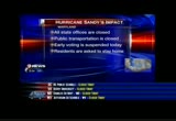
6:21 am

people. that's about a fifth of our national population. millions of those people are in the new york city area where there is an evacuation order for portions of all five borrows. subway -- boroughs. subway and bus service has been suspended ahead of the massive storm. the city has also closed schools today and ordering some residents in low lying areas to leave. >> they're expecting a 7-foot storm surge in lower manhattan and ie even was 4.-- irene was 4.1. >> district a in lower manhattan was the bully's eye point and it's definitely that again. >> expecting 20-foot waves on the barrier beaches. >> the airports have been closed. >> probably will be for a couple of days. today, tomorrow, you can pretty much forget. i feel for the businesses that lose today, like a restaurant can't make up lost sales. >> they can't but it's better to be safe this afternoon sorry
6:22 am
-- safe than sorry. >> no question about it. let's talk about the storm itself and give you that forecast for today. as you can expect heavy rain and wind. in fact the rain and winds will be increasing here. rain first. it's picking up already from the east. the winds will follow this afternoon. by 6:00 as we dip into the upper 40s, we're showing you we've got northwesterly winds at about 40 miles an hour. those are sustained winds. we're thinking we could be seeing gusts 50 to 60 by 6:00 p.m. and maybe 70 or more tonight as the storm comes ashore. we've got basically hurricane warnings from the virginia- maryland boarder up into southeastern massachusetts, including the chesapeake bay. so we've got coastal flood warnings as well. going to see tides 1 to 3 feet above normal. we have a full moon. on the ocean, that's where we could be having a ten-foot or more storm surge just along and north of the path of this strengthening hurricane. winds will pick up to 90 potentially this afternoon. will it be 85, 90, 95 when it
6:23 am
makes landfall? tough call there but it does look like the storm is strengthening at the moment and will be making landfall around 10:00, 11:00 near atlantic city. it will be a devastating storm for most of coastal new jersey, new york, long island. and in our area we'll certainly get plenty of wind and rain. that will cause trees to come down. i would expect massive power outages from the mid-atlantic through parts of the northeast. windses still by tuesday afternoon 60 miles an hour. then by wednesday morning, 40 miles an hour. so we still have a long, long way to go with sandy before we're done with this. i want to show you the late e winds and waves -- latest winds and waves. we have waves 20 to 30 feet on the west side. locally there's a buoy i've been watching about 15 miles east of rehoboth. gusts to 49. the wider the sustained winds,
6:24 am

the bluer the gusts. the wave heights 23 feet off shore working its way toward the west gusting to 39 at ocean city. 39 norfolk. our winds in d.c. north at 20. they will increase. we've been watching the moisture come on shore. already five inches of rain reported on the northern neck, parts of the eastern shore. this is snow in the mountains of west virginia. lauren, say that one more time? 30. got to show you this quickly as the rain is moving in from the east. the heavy stuff just about to move into d.c. west of town we still have some lighter showers going on but it is going to be getting worse and worse throughout the middle of the day and into the afternoon. 52 today. dropping temperatures, increasing wind. again could be gusting 50 to 60 by this evening. maybe 70 or more overnight. tomorrow still having gusts 65 to 70 in the morning. then some showers in the afternoon but 46. wednesday showers, yellow alert with the winds breezy. shower or two, 56. finally by thursday i think some more sunshine 56.
6:25 am

this is the weekend we fall back with the time change saturday night into sunday morning. let's go over to monika samtani at 6:25. timesaver traffic. we just have to make it to the weekend. we just have to make it through the next few days. luckily many of us were preparing over the weekend. right now all the information you need to know about public transportation is that most of it is closed. metrorail bus, metro access, ride-on, all service suspended. we were just on the phone with the metro speaks person and they'll -- spokesperson and they'll make the decision about tomorrow later in the evening. i think it will be the same thing tomorrow for safety sake as well. storm closures, i was on the phone with maryland's park police. they tell me in anticipation of flooding beach drive closed down for a section. little falls parkway between mass avenue and river read and sligo creek parkway. be aware of those storm
6:26 am

closures. if you're planning to head over to the airports, the airports are open but most of your flights are canceled in the northeast corridor. if you're planning to head on to a flight and you think you may have a chance of getting on, call ahead. if you're planning to use marc, acela, vre, dash bus, fairfax connector or amtrak, all are closed for today. if you're planning to use the bay bridge, wind restrictions. it's a level one wind restriction which means no house or empty box trailers. a quick look outside and show what you it looks like if you're planning to head here on 270, of course it's going to be lighter than normal. those of you who do have to get to work, keep the speed limits down. treat all intersections where you don't see the signal lights on, treat it as a fourway stop. we'll have more news on sandy when we return. you're watching 9news now. stay with us.


6:30 am

welcome back. 6:29. your weather first. we're looking at the rain and winds increasing. the rain has picked up from earlier. we have a temperature of 53. rain will increase, 52 by noon. down to 50 by 5:00. by then we could have winds gusting to 50 miles an hour, maybe more. looking at a very powerful hurricane. even though the winds are 85 miles an hour since 9:46 reconnaissance has found pressure dropping again to 942 with gusts 105. it has an enormous wind field. extending about 450 miles from the center. looks like the center will be passing south of atlantic city about 10:00 tonight, strengthening to 90, maybe even stronger when it makes landfall. then it will be pushing across northeastern maryland into south central pa. so that means for us an extended period of potentially very damaging winds starting later this afternoon through midday on tuesday. i mean winds which could gust to 70 or more even here in d.c.
6:31 am

wave heights 30 feet east of hatteras. 25 feet east of virginia beach. 23 feet, about 15 miles east of rehoboth with gusts almost 50 miles an hour just off shore. 39 miles an hour gusting in ocean city. we have a north wind at 20 miles an hour here. look at the rain as it's coming in from the east. heavy now from d.c. east with mountain snows. temperatures low 50s this morning. we'll be 50s, if not upper 40s by the end ever the day and staying in -- of the day and staying in the 40s tomorrow. we'll have a lot more on sandy in a few minutes. right now andrea. >> thank you, howard. montgomery county is prepared to help its residents affected by hurricane sandy. joining me is lucy from the local county government. the government is closed but central personnel are supposed to report like you. how is the county preparing to help its residents just in case. >> yes, the essential public safety personnel are on duty. and we've talked about those high winds. that means trees are going to
6:32 am
be coming down. we want to make sure our community members know that if a tree comes down on private property in montgomery county, call our call center. it opened at 6:00 a.m. this morning. you can file a report also online at www.mc311.com. it's important for people to know if a tree comes down and live wires are involved or the tree is blocking a roadway or the tree is on a structure, if anyone is trapped, then you call 911. otherwise you call 311 in montgomery county. >> you talked about the 311 for downed trees on park or public lands. if it comes down on your private property, that is not a call that should go to 311 unless it involves the live wires? >> that is correct. if it is on private property, that would be for the homeowner to deal with unless there's an
6:33 am

impact with live wires or a personal emergency. >> as long as people have power, how else can they be in touch with montgomery county government as far as what's happening in the county? are there alerts that they can sign up for? >> yes, absolutely. the montgomery county alert. we have been pushing out information. we hope that everybody has signed up for that by this point. but we have information on our montgomery county website. that's www.pons gomry-- montgomerycountygovernment acom . it's important for for people now while they have power to print up the emergency information that's posted on websites su'have it to refer to once the power goes off. >> good piece of advice. it sounds as if montgomery county government is prepared for a long haul during this storm. >> we are as are all the
6:34 am
municipalities. >> lucille bower from montgomery county government speaking to us. all maryland government offices are closed today except for essential personnel. public transportation across the state is also closed. maryland residents are urged to stay home to try and keep area roads clear for emergency personnel. all early voting activities have been suspended today. early voting hours missed today will be rescheduled for friday. maryland governor martin o'malley said that decision to shut down the government was made to remain consistent with the district as well as the federal government. in virginia no absentee voting today in fairfax county. the county is also set up an emergency information line for its residents. that phone number in fairfax county is 571-350-1300.
6:35 am

it can be used 24 hours by fairfax county residents who have questions related to hurricane sandy. but this number is not to be used if you have an actual emergency. for real emergencies like live wires on your property or downed trees that brought down live wires, call 911. as we mentioned earlier, all d.c. government buildings and facilities are closed today. early voting has also been suspended in the district. starting at 10:00 this morning, five d.c. public recreation centers will operate as emergency shelters and recovery sites. they include guy mason recreation center on 3600 calvert street in northwest. emery recreation center at 5801 georgia avenue in northwest. turkey thicket recreation center at 1100 michigan avenue northeast and the deanwood recreation center at 1350 49th street northeast. also bald eagle recreation center at 100 jol jeet street
6:36 am

-- joliet street southwest. residents are asked to call 311 to report downed trees. call 911 for true emergencies. and all d.c. residents are urged to stay home and indoors. montgomery county shelters will open beginning at noon today. three locations. white oak community reck nation center at 1700 april lane. that's in silver spring for people and pets. the activity center at bohrer park at 506 south frederick avenue, gaithersburg for people only and also for people only, the mid county community recreation center at 2004 queensguard road in silver spring. prince george's county will have two shelters available for residents. the ch flowers high school located at 10001ardmic -- ardwick ardmore road. also the ritchie coliseum at
6:37 am

umd located at rossborough drive in college park. the united way of the national capital area servicing all our region want you to know help is available if you need it. virginia, maryland or d.c. residents without power, out of food, need shelter or any number of vital services can call 211. there are trained multilingual operators manning the phones 24 hours a day. of course for life-threatening emergencies, do call 911. it's 6:37. you're watching 9news now. we'll be right back.


6:41 am

we're back at 6:41. this is always the place to get your weather first n. is a live -- first. this is a live look atra hoe both beach. -- at rehoboth beach. the rain is picking up. the wind is picking up. it's cold in our area. 53 degrees. >> the waves are only going to get bigger. this thing will not make landfall till 10:00, 11:00 tonight. >> we're getting questions from people who are watching us at facebook and on twitter. thank you for joining us for 9news now. we heard from don lambert mentioning that people should make sure to get your prescription medicines. the pharmacies will be closed. topper has been very big on that one. from chris on facebook, will there be tornadoes in the storm?
6:42 am

>> not likely. this is a good question. when we have tropical landfalling storms, whether it a hurricane or tropical storm, to the right of the path is where you can get enough wind sheer where you normally can get tornado watches or tornadoes from that. if there were going to be any tornadoes depending on the nature of the system and it's a little chilly, it would be to the right of the pact. maybe central -- pact. maybe central and northern new jersey would have a better chance of tornadic activity than here. >> howard will answer all of your questions. just send them into us at facebook at twitter. he loves to talk to you. >> you can follow us here at wusa9. on facebook right now, they're doing account maintenance so i can't post for a few minutes. i have a lot of animations and other graphics i have been putting out there the last couple of days. let's talk about the day ahead because it's going to go downhill even more so and rather quickly this afternoon. >> the weather app page is
6:43 am

still working beautifully. >> you can always download the weather app. text sandy to 25543. we've got temperatures steady or slowly falling today. 51 degrees by 4:00. by 8:00 we'll be in the upper 40s. by 8:00 we've got westerly winds at 45. they could be gusting to 65 by then. it's really going to be tonight, probably 8:00, 9:00 till about midday tomorrow will be the worst of it. yes, it's going to get that much worse with a storm 85 mile an hour winds gusting to 105. at 946 millibars, this would tie the 1938 storm that hit long island as the lowest pressure north of cape hatteras. saw a consans report -- saw a reconnaissance report. we're dealing with probably a devastating storm when it makes landfall late this evening, 10:00, 11:00 just south of atlantic city. this is going to produce
6:44 am

tremendous rains and wind across our region as well. gusts 6 for to 70, maybe more than that as we get through the evening and overnight period. by tomorrow morning 2:00 a.m. it will be passing philadelphia. by 2:00 p.m. it will be maybe passing harrisburg. that's a long time. philly to harrisburg 12 hours, that is not a quick moving storm. then making the turn north and starting to pull away as we get into wednesday. we'll be dealing with this for 36 to 48 hours. waves off of hatteras 29 feet. 25 feet east of virginia beach. you saw the video at the top -- with andrea and i. we were showing you the waves from rehoboth beach. wave heights right now 23 feet. winds gusting close to 50 miles an hour. on shore ocean city down to wallace, gusts in the mid- to upper 30s. here in town we have sustained winds outs of the north at 20 miles an hour. snow in the mountain. rain starting to move n. blizzards warnings there. it will be bad above 3,000
6:45 am

feet. the rains get heavy from d.c. to points east. one report of 3.2 inches of rain overnight from reedville in the northern neck. the forecast going downhill quickly. you still have a few hours to maybe secure your lawn furniture, clear the leaves out of the drain. 52 and dropping. tonight we dip into the 40s and pretty much stay there tomorrow. heavy wind and rain in the morning. could still get 65 mile an hour gusts in the morning. better in the afternoon. still very windy. wednesday showers, breezy, 56. thursday just partly sunny 56. passing shower friday and this weekend, warmer sunday. we turn the clocks back. getting a much needed hour of sleep. it's 6:45. here's monika with timesaver traffic. >> don't you wish it could just be thursday. it will be soon enough but we have a lot to deal with before that. good morning, everybody. i was just on the phone with laura over at maryland state highway to get an update on things in maryland, including what's happening on route 50. you have the wind warnings in
6:46 am

effect at the bay bridge and then further east on route 50 if you were planning to head to the beach, of course not a good idea. by the way eastbound route 50 is closed at gulf course road. maryland 90 is open but they do not want you to head over to that area. eastbound route 50 right now is closed at golf course road and you have the wind restrictions again at the bay bridge. so keep that in mind. that will change throughout the day in terms of your wind warnings at the bay bridge. let's go to our next camera shot live. if you are planning to head to the northbound side of 395, everything is open. there have been no big incidents this morning. of course a lot of you do have to get to work. this is what you should expect. basically along 95 and 395 up toward the 14th street bridge. all of the anacostia and potomac river crossings are doing fine. for those of you who do have to go to work especially as you head into the district, you'll want to know as our power outages occur because they will later in the day, they will affect major intersections. there are about 200 generators in place in the district at the
6:47 am

major intersections. you'll want to treat it as a fourway stop if it's dark. let's take one more look outside if you're planning to head here on 66 and nutley street. that's incident free. still looking very good from nutley street. a quick look at a graphic. public transportation canceled. metro, marc, acela, vre, dash fairfax -- dash bus, fairfax connector and amtrak all closed. we're taking a look around the region to see how conditions are changing and affecting the people who live there. right now we want to go to ko im in chesapeake beach. who do you have as your guest and how are conditions fairing now? >> reporter: good morning, andrea. the rain is pretty much the same. the winds haven't picked up a lot just yet. we're joined this morning by jimmy king. thank you for joining us this morning. how are you? >> i'm fine, thank you. >> reporter: we saw you this
6:48 am

morning in your car looking at your charter boat. you have some concerns about that during hurricane sandy? >> sure. just watching the weather, watching the boat, making sure everything is secured. don't want nothing to break or get loose. >> reporter: we talked about isabel and how bad it was for this town. can you tell me what you remember from then? >> yeah. we had high waters, quite a surge. the water was probably about four and a half foot, five foot surge of water in the harbor here. it scoffed the parking lot. it was -- it covered the parking lot. it was pretty extreme. >> are you worried about your home up in north beach? >> a little but more so my boat in the water. i'm worried about the surge of water and high water we may get. >> reporter: this parking lot we're standing on, we're told it was actually elevated a couple of feet. it could still possibly could get flooded with water later. thank you, mr. king. we'll let you go back in your vehicle and get warmed up. in the meantime we'll show you
6:49 am

what's below this parking lot. as you can see -- if you can see from the cameras's vantage point, the water is coming up to just about maybe one and a half feet from the edge. and the boats are rocking a little bit. the winds again have not picked up yet. again the town wants you to to stay home so that crews when they need to can get out safely and have all access. we'll send it back to you in the studio, andrea. >> thank you, ko im is reporting live from chesapeake beach in calvert county. if you're in the immediate d.c. area or to the west, you probably have a little time left to prepare for a power outage. so we advise you now to charge your cell phone, dim the brightness feature on your phone and turn off any unnecessary apps to conserve battery power. make sure your digital camera has fresh batteries so you can take photos of any storm damage. you'll need that for your insurance company when you make
6:50 am

a claim. if you have any halloween deck rakes you put -- decorations you put up, take them down. even a small pumpkin can cause damage if it's hurled by strong winds. no trash pickup today in d.c. because of the expected high winds. we'll be back after a quick break with the latest on hurricane sandy. we're following it as she moves up the coast. we'll be right back.


6:54 am

good morning. welcome back to 9news now at 6:54. we're going to head across the potomac into virginia. jessica doyle is live from old town alexandria which is used to flooding and people are ready. sandbags are there. jessica, what's it looking like now? we're having some problems with jessica's audio. let's see if we go back across
6:55 am

the water to the beach front atra hoe both -- at rehoboth beach. people were ordered to evacuate the area because of the anticipated high flood waters. kristin fisher hopefully is there with conditions in rehoboth beach. kristin, can you hear me? there she is. chris continue, you're up. >> reporter: i -- kristin, you're up. >> reporter: i hear you. are you talking to me? >> we are. >> reporter: the last time you saw me we were over on the bay side. right now we're on the boardwalk of rehoboth beach. you can see all of the businesses, candy kitchen, grotto piz disarks all the ie -- pizza, all the icons boarded up. there is nobody out on these streets. let's look at the surf. check out the waves coming in. huge waves, 14, 15 feet, getting higher as sandy comes closer and closer.
6:56 am

the center of the storm still about 300 miles away from us. expected to make landfall in several hours just north of us on the southern new jersey coast. what we're hearing this morning is that -- the good news, i'll start with that. not a ton of power outages. just under 2,000 overnight. that's the good news. the bad news, lots of road closures, lots of flooding. route 1 into dewey beach, bethany beach totally closed. wiped out. here's actually some pretty big news we just found out from the governor of delaware. even though there's a mandatory evacuation order in effect which means if you decided to stay, law enforcement most likely will not be able to come and get you. some people are trapped about 15 miles south of here, trapped in flooding. the national guard and local law enforcement are in the process of going in and trying to get them out. so some folks did not heed that
6:57 am

warning. it's starting to get a little bit dicey as hurricane sandy moves a little closer to us. i want to show you all a little bit more of the boardwalk, kind of our setup here. if we take a look down this way towards where we're staying at the atlantic sands hotel, you can see completely deserted but not a ton of flooding on the boardwalk yet. that's some great news. keep in mind we're still about an hour away from high tide. if we go down -- excuse me. tripping over this cord here. if we go down over this way, you can see we've got lights still on. power still going strong. not a ton of debris. i've got to say we're looking pretty good over here on the boardwalk side. again it's the bay side that people are so worried about. i think as we're standing out here, what's really shocking is just the fact that we have been feeling these sorts of conditions for well over 12 hours now. look, here comes the surf starting to roll in. if we can actually -- hey,
6:58 am

chip, our photographer, look at these waves over here. can you all see the size of these things? i mean, it is really starting to pound the beach. we're seeing a significant amount of some beach erosion and actually, chip, if we come down a little closer along the beach shore, look right here. you can see the start of some of the fentsing starting to be -- fencing starting to be torn down by the surf. i think so far so good on the boardwalk. this is something that folks here are very used to. right now it's looking pretty similar to what these folks saw during hurricane irene but again i think the big issue here in rehoboth beach and rest of the delmarva peninsula will be on the bay side as the storm surge starts to come up because again we were out there yesterday. lots of flooding well before this thing ever hit. we were there about an hour ago and it was -- i mean, i was standing in several feet of water. it's coming in. it's getting worse. it's very cold out here and
6:59 am

getting colder. very windy although the wind gusts have started to die down a bit. really folks just sort of hunkering down and waiting for the worst of this storm to come because it is not over yet, far from it. i'm going to scoot back a little bit so you all can get a better shot of the surf. it's really quite impressive. folks heeding the warnings. no folks on the roadways. no folks walking around. let's hope it stays that waip. back to you guys. >> get back in the truck. get the hands warm and dried off. we'll be looking forward to your updates later on in our newscast. thank you. again we are tracking this storm. we'll be right back with the very latest from howard on where sandy is going and from monika on what's open and what's closed as far as roadways in the area. you're watching 9news now.
245 Views
IN COLLECTIONS
WUSA (CBS) Television Archive
  Television Archive News Search Service
Uploaded by TV Archive on
